Into the White Mountains
New Hampshire Trail Guide · June Edition
Into the White
Mountains
June is New Hampshire's secret season — wildflowers in bloom, waterfalls running strong, and the long days of summer just beginning. Here's everything you need to lace up and go.
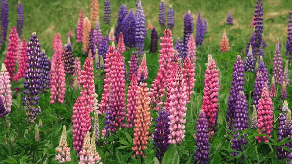
June is when New Hampshire truly wakes up. The mud of May has begun to firm, the black flies are (mostly) receding, and the trails come alive with color. Lupines carpet the valleys of Franconia in waves of violet and pink. Alpine wildflowers push through granite ledges at elevation. Waterfalls — swollen with snowmelt — roar through narrow ravines with a force you'll feel in your chest.
It's also one of the last months before the summer crowds fully arrive. Hit the trails on a weekday morning and you may share the summit with only the wind. This guide covers three of the finest hikes in the state — one for every experience level — along with everything you need to know about trail conditions, wildlife, hazards, and where to park your car.
Mount Major
Mount Major is arguably the most beloved hike in southern New Hampshire, and with good reason. The summit delivers a panoramic reward entirely out of proportion with the effort required: a sweeping 360° view of Lake Winnipesaukee's 274 islands, the White Mountains rising to the north, and the Belknap Range spreading in every direction. At the top, you'll find the ruins of "Mr. Phippen's Hut," a stone shelter that has become one of the state's most photographed landmarks.
Trailhead parking lot is on the west side of NH Route 11 in Alton — 5.4 miles north of Route 140, 4.2 miles north of Alton Bay. A Forest Society kiosk and pavilion mark the lot. Arrive before 8 AM on weekends — the lot fills completely and overflow parking spills half a mile down Route 11.
Take the Main Trail (blue blazes) right from the parking lot, ascending a steep logging road. At 0.7 mi, the Brook Trail (yellow) splits left — take it for a more gradual, shaded ascent. The upper ledges are steep. Loop back on the alternate route for a fuller 3.7–4.8 mi experience.
Trails are generally clear and passable. Expect some muddy sections in the lower forested stretch, especially after rain. The upper rocky ledges dry quickly. Upper ledges can be slippery when wet — use caution and avoid in thunderstorms.
One of the most heavily trafficked hikes in the entire state. Weekends mid-morning can see hundreds of hikers. Go early on weekdays for relative solitude. The trail is far more pleasant before 9 AM.
What you'll see from the summit: The entirety of Lake Winnipesaukee stretching south, with the Ossipee Range to the east and Mount Washington visible on clear days to the north. The ruins of the stone hut invite a long rest and a picnic — bring a sandwich and take it all in.
Welch–Dickey Loop
If Mount Major is New Hampshire's most popular hike, Welch–Dickey is its most underrated gem. This 4.4-mile loop traverses two summits connected by open granite slabs that feel like hiking across the back of a sleeping giant. The views begin early and rarely let up — for a hike that stays well under 3,000 feet, the exposure and panoramas rival much taller mountains.
From I-93, take Exit 28 toward Waterville Valley. Follow Route 49 east for about 4 miles, then turn left on Upper Mad River Road. The Welch–Dickey trailhead parking area is 0.7 miles ahead on the right. A White Mountain National Forest Recreation Pass (or day pass) is required. Parking fills on summer weekends — arrive by 8 AM.
Start on the Welch Mountain Trail from the far left of the parking lot. Hike clockwise: up Welch Mountain first (summit at 1.4 mi), then the exposed ridge connecting to Dickey Mountain (summit at 2.6 mi), then descend via the Dickey Mountain Trail back to the trailhead. Do NOT attempt counterclockwise — the descent of Welch's ledges is significantly more treacherous.
Mid-to-late June is ideal — snow-free, wildflowers blooming on the open ledges, and streams running well for water. The granite slabs can be slick after rain; poles help. The trail is best from mid-May through October.
Moderately busy on weekends, quieter than the White Mountain 4,000-footers. June weekdays offer a relaxed pace. You'll typically share the summits with 10–30 people on a nice Saturday morning, far fewer on weekdays.
What you'll see: The Mad River Valley unfolds below, with Waterville Valley ski area visible across the way. Mounts Osceola, Tecumseh, and Tripyramid dominate the northern skyline. On clear days you can pick out Franconia Ridge. In June, the open ledges between summits erupt with wild blueberry bushes, wood sorrel, and mountain sandwort in bloom.
Franconia Ridge Loop
Franconia Ridge Loop is the crown jewel of eastern hiking — consistently ranked among the finest day hikes in all of North America. The 1.7-mile alpine ridgeline connecting Mt. Lincoln and Mt. Lafayette offers unbroken 360° views in every direction, with the rocky spine curving dramatically between summits above the treeline. In June, wildflowers bloom in the krummholz and cascading waterfalls mark the beginning of the Falling Waters Trail. This hike will leave you breathless in every sense.
Take I-93 to Exit 34A (Franconia Notch Parkway). Follow signs to the Lafayette Place Campground on the west side of the Parkway. The trailhead is on the east side, across the road from the campground. The lot is enormous but fills by 7–8 AM on summer weekends. If it's full, park at the Peabody overflow lot and take the free hiker shuttle (runs weekends and holidays, late May–October, cash only).
From the trailhead, take Falling Waters Trail south/east. Pass Stairs Falls (0.8 mi) and Cloudland Falls (1.6 mi — stunning in June). Continue steeply to Little Haystack summit (3.2 mi). Turn north on Franconia Ridge Trail over Mt. Lincoln, then Mt. Lafayette. Descend via Old Bridle Path back to trailhead. Restrooms at trailhead and at Greenleaf Hut (4.5 mi).
Early June may still have ice patches on the north-facing summit slopes — microspikes advisable before June 15. By mid-to-late June, trails are clear. Waterfalls are at peak flow in June (don't miss Cloudland Falls). Weather on the ridge changes rapidly — temperatures drop 3–5°F per 1,000 ft gained. Bring layers even on warm days.
This is one of the most hiked trails in New England. Expect 100–300+ hikers on a sunny summer weekend. The lot fills by 7 AM. On weekdays or in marginal weather, the ridge becomes beautifully serene. Start before 7 AM for the best experience. The Greenleaf Hut (staffed AMC hut) offers snacks, water, and restrooms at mile 4.5 — a welcome mid-hike stop.
What you'll see: From the ridge, virtually all of the White Mountains spread before you — the Presidential Range marching north toward Mount Washington, the Kinsmans to the west, and on crystalline days, the Green Mountains of Vermont beyond. Cloudland Falls, with its 80-foot cascade, is one of the finest waterfall sights in the state. The lupine fields in the Franconia and Sugar Hill valleys below bloom brilliantly in early June — visible from the ridge as sweeping fields of purple and white.
What You'll Encounter
Wildflowers in June
- Lupine (valleys & roadsides, peaks in early June)
- Painted trillium (forest understory)
- Wild azalea / rhodora (bogs and streamsides)
- Mountain sandwort (exposed granite ledges)
- Clintonia / yellow bead lily (shaded forest trails)
- Bunchberry (low-elevation woodlands)
- Wood sorrel (along streams and rocky slopes)
- Alpine Diapensia (above treeline, late June)
- Pink lady's slipper orchid (rare, protected)
Wildlife You May See
- White-tailed deer (meadows, early morning)
- Moose (wetlands, especially at dawn and dusk)
- Black bear (berry patches, forest trails — rare but present)
- Peregrine falcon (nesting on cliff faces in June)
- Common loon (lakeside trails and pond crossings)
- Red-tailed hawk and osprey (soaring thermals)
- American toad (streamsides, abundant in June)
- Eastern chipmunk and red squirrel (trail-side)
- Porcupine (night forager, sometimes seen at dawn)
Summit Views to Expect
- Lake Winnipesaukee & its 274 islands (Mt. Major)
- White Mountains panorama from south NH peaks
- Mt. Washington on clear days from most summits
- Franconia Notch valley from the Ridge
- Vermont's Green Mountains (Franconia Ridge)
- Mad River Valley and Waterville Valley (Welch–Dickey)
- Lupine valley fields in early June (from above)
- Atlantic Ocean on exceptional visibility days
June Weather Patterns
- Valley highs typically 65–80°F in mid-June
- Summit temperatures 15–25°F cooler than valley
- Afternoon thunderstorms common — start early
- Morning fog in notches burns off by 9–10 AM
- Mt. Washington weather is unpredictable year-round
- Wind speeds above treeline can reach 40–60 mph
- Waterfall volume at annual peak in early June
- Some snow possible on 4,000+ ft summits before June 15
Hazards to Know
Black Flies
June is peak black fly season in NH. Lower-elevation and shaded forest trails are worst. Wind above treeline provides relief. Apply bug spray (DEET or picaridin) and consider a head net for lower trails early in the month.
Tick Habitat
Deer ticks (Lyme disease) are active from spring through fall. Risk is highest in meadows and shrubby terrain below 2,000 ft. Wear long pants, tuck socks, and do a full body check after every hike. Check dogs thoroughly too.
Afternoon Lightning
Thunderstorms build rapidly over the White Mountains on warm afternoons. If you're on an exposed ridge and hear thunder, descend immediately. Start high-elevation hikes before 7 AM to be off summits before 1–2 PM.
Slippery Wet Ledge
Granite slabs on trails like Mt. Major and Welch–Dickey become dangerously slick when wet. Avoid these trails on rainy days or immediately after rain. Approach upper ledges with extreme caution in wet conditions.
Black Bears
NH has a healthy black bear population. Bears are generally timid and avoid humans. Store food in your pack — never leave snacks unattended at summits. If you encounter a bear, make noise and back away calmly. Do not run.
Residual Ice (Early June)
Before June 15, north-facing slopes above 4,000 ft — especially on Franconia Ridge and in Tuckerman Ravine — may still hold ice. Microspikes are advisable for any 4,000-footer before mid-June. Check trail reports before you go.
High Water Crossings
Snowmelt swells NH's streams through early June. Some trails involve brook crossings that may be thigh-deep in early season. Poles help with balance. Use a trekking pole to probe depth. Never cross swift water above knee height.
Hypothermia Risk
Even in June, summit temperatures with wind chill can drop below 40°F. Wet hikers cool fast. Always carry a mid-layer and rain jacket regardless of the valley forecast. Hypothermia is possible in above-freezing temperatures when wet and windy.
Ten Things to Know Before You Go
Start Early
Parking fills by 7–8 AM at popular trailheads on summer weekends. Arrive at dawn to beat the crowds and afternoon storms.
Pack the 10 Essentials
Navigation, sun protection, insulation, illumination, first aid, fire, repair tools, nutrition, hydration, shelter. Non-negotiable in the Whites.
WMNF Recreation Pass
Most White Mountain National Forest trailheads require a recreation pass ($5/day or $30/year). Buy at the trailhead or online in advance.
Dogs on Leash
Most NH trails allow dogs. In WMNF you must carry a 6-foot lead. Keep dogs leashed in alpine zones — fragile vegetation and loose footing are real hazards for paws.
Check Trail Reports
Visit the AMC White Mountain Trail Conditions page or AllTrails before heading out. Conditions change fast in June, especially at elevation.
Leave No Trace
Pack out all waste including dog waste. Stay on marked trails. Don't pick wildflowers — pink lady's slippers are protected by state law. Pack out what you pack in.
Categories
Recent Posts